Glorious scenery, fine local food and the convenience of the Spirit makes Devonport a great base for exploring the enticing north of Tasmania, finds Jon Miller.
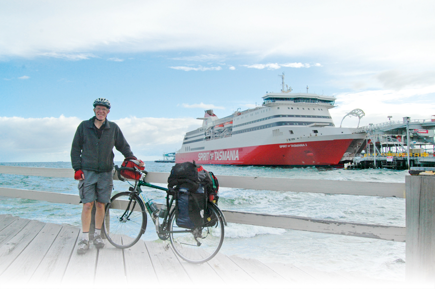
As I get closer to Station Pier in Port Melbourne the massive, red hull of the Spirit of Tasmania takes up more and more of my field of view. I feel excited – on the verge of an adventure – and as though my holiday has started before I get on board.
I queue up with the cars to collect my boarding pass and then board with the foot passengers. There is a small alcove just inside the entrance way of the ship for bikes and a couple of straps are supplied for securing them. I decide to use an occy strap plus a small cable lock, just in case.
My partner, Fiona, drives straight from work and queues for her boarding pass, and then again to drive on. Still, when we meet up in our cabin, we agree the process is a lot less stressful than getting out to the airport.
There’s plenty to do on board, bars, shops, TV screens, movies in the theatrette but we spend most of our time relaxing over dinner in the Leatherwood Restaurant. Tasmania has marketed itself as a foodies’ destination and that experience starts with the ferry crossing. The emphasis in all the restaurants on board is for Tasmanian supplied products. I’m no restaurant critic but I know good food when I taste it and this is excellent. Our friends back home are quite envious as we post photos of the desserts on Facebook for them to drool over.

After a comfortable night’s sleep, we arrive in Devonport at 6am the following day. When you mention Tasmania to most people, they think of the major cities of Launceston and Hobart or the national parks, including Cradle Mountain – Lake St Clair. However, there’s much more to the state than this limited view. Devonport makes a good base for exploring the north coast region. The ferry terminal means that there is a large range of accommodation available. These range from several caravan parks through to backpackers, pubs, motels, B&Bs and hotels.
The Devonport ferry terminal is actually in East Devonport, just inside the mouth of the Mersey River. While there are a few shops and cafes open early to catch the ferry traffic, most of the action is in Devonport itself on the opposite bank of the Mersey. To get there, you have to ride south for 2km to the nearest bridge. Unfortunately, you are on the same roads as the cars and trucks disembarking. There are no bike lanes marked, though the roads are wide enough that they could easily be added and council are working at improving the access for bikes. Once at the Victoria Bridge, there is a shared path over the Mersey and up the other side in to Devonport itself.
There is also a small ferry, the Spirit of Devonport, which transports foot passengers and bicycles across the river. This leaves from just behind the Spirit of Tasmania but you can’t simply follow the waterfront to get there. You must exit the quarantine area; turn left up Wright Street then the next left on Thomas Street back to the river bank. However, the first ferry doesn’t leave until 7:30 am so you might want to have a leisurely breakfast in East Devonport before making the crossing.
West to Penguin


Distance 35km
Surface Good quality bitumen or concrete path and sealed roads
Difficulty Easy apart from the big climb out of Don
Scenery Coastal views, tea-tree and other native forest, open farmland with lush pastures and a lot of bird life.
One of the most scenic roads in Tasmania is the quiet coastal road to Penguin, just 35km west of Devonport. From Central Devonport, make your way down to the Mersey River where you will find the beginnings of the Don to Devonport Cycleway. This is a 7km concrete and bitumen rail trail that runs north along the Mersey River bank past the working freight terminal, heads west along the Bass Strait coastline past Mersey Bluff with its magnificent coastal views and Coles Beach before turning south along the bank of Don River through wetlands and tea-tree to Don. The Cycleway finishes at the historic Don Station, home to the Don River Tourist Railway with restored locomotives regularly plying the route between Don and Coles Beach. There’s also a selection of pleasant walks to do in Devonport.
The shared path between Turners Beach and the outskirts of Ulverstone is the gold standard
From Don, follow Forth Road inland as it passes underneath the freeway and up the hill. It’s about a four kilometre climb and the first 2km are quite steep but that’s the only real hill of the day. As you get higher, the views get more expansive over vast tracts of farmland and occasional glimpses of the coastline far away in the distance. It’s a ripper of a descent into the pretty little town of Forth before the road flattens out and heads back towards the beach.
Take the right turn on Turners Beach Road just as you enter the township of Turners Beach. Follow this through the roundabout and over the freeway towards the railway line. It’s easy to miss the bike path, so look out for it on your left immediately before the level crossing.
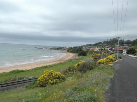
The shared path between Turners Beach and the outskirts of Ulverstone is the gold standard of shared paths. It is at least three metres wide, has a very smooth surface, no blind corners and is quite scenic to boot. Birds like the area too from the tiny yellow-throated honeyeater to the majestic Cape Barren geese and comical Tasmanian native hens. Bicycle! Bicycle! blog has an enthusiastic post about this trail.
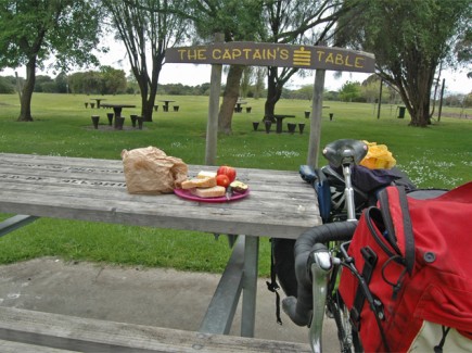
Arriving in Ulverstone, you ride through a coastal reserve which could be like every other non-descript coastal park in the country. Except the council has made an effort and erected some amusing signs around the place. The barbecue area is the “Rock Inn BBQ”, the picnic tables are the “Captains Table” and that sort of thing. It’s converted an ordinary little park into a fun place to be.
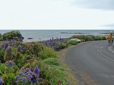
You must cross the Leven River in Ulverstone via the recently upgraded Hobbs Street Bridge, a nice, wide pedestrian and cycle path. Turn right over the bridge up Queen Road, following the alternative route signs to Penguin. Soon you swing round to the left and follow Penguin Road along Bass Strait into Penguin. This is a beautiful road to ride along, there are a few little ups and downs with some glorious coastal views. The Three Sisters, small rocky islands just off the coast, are particularly picturesque.
The last kilometre or so before Penguin was like riding through a kaleidoscope of colour. Small bushes lined both sides of the road and they all seemed to be in flower as I rode through. The first shop I came to was The Chocolate Shop but I continued on towards the bakery.
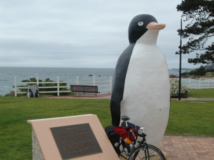
Penguin was quiet in spring but its pretty little beach must get busy in the summer. It’s probably busier on a Sunday as well when it hosts Tasmania’s largest undercover market with over 200 stalls. The town was named the after the fairy penguins that come ashore at dusk. These are still in the area but you are unlikely to see them as they avoid populated areas. Get your photo taken with the large fibreglass penguin in the main street instead.
South to Sheffield

Distance 35km
Surface Varies from bitumen to packed earth trail to gravel road
Difficulty Medium
Scenery Magnificent river views, native and pine forest, open farmland, views of Mt Roland near Sheffield
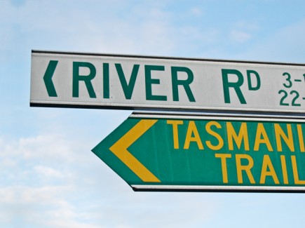
The Tasmanian Trail is a mostly off-road cycling trail which spans the state from Devonport to Dover, south of Hobart. While it’s primarily aimed at mountain bikers, the first part of the trail from Devonport to Sheffield covers about 23km on sealed roads with the last 12km or so on the Railton to Sheffield Rail Trail. The surface, though rough in places, is suitable for hybrids and touring bikes as well as MTBs.
From the ferry terminal, follow the signs south towards Devonport. The road passes under the main Bass Highway before looping around over the Victoria Bridge. It’s on this loop you have to make a right hand turn on to River Road. It’s signposted to Latrobe and there is also a small green and gold Tasmania Trail signpost.
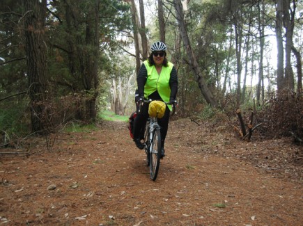
River Road follows the eastern bank of the Mersey River. It’s a very quiet road, well used by locals out for an early morning ride. If, like me, you ride this straight off the ferry, you will be rewarded with the soft, golden morning sunlight reflecting off the water, penetrating the mist which is rising gently from the surface.
After 9km of this, you reach the intersection of the B19 on the outskirts of Latrobe. You can turn left to head into Latrobe or turn right then left a few hundred metres later on to the undulating B13 to continue on towards Railton. This road is busier but I soon learnt that Tasmanian motorists are more patient than their mainland counterparts. They won’t try to squeeze between you and oncoming traffic but will wait for the road to clear. There’s no blasting of horns or revving of engines as they pass, just a polite wave.
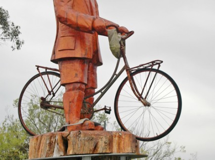
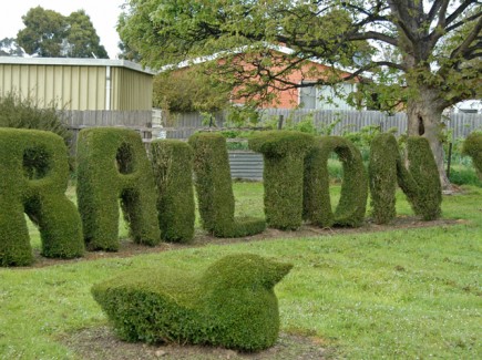
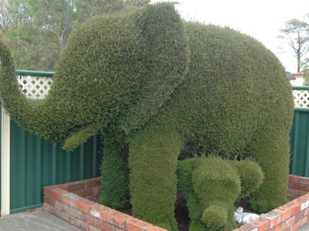
Railton is a sleepy little place. It’s claim to fame being the Town of Topiary. There are dozens of artfully shaped hedges scattered throughout the town. You can pick up a leaflet and map from the tourist office but it’s also fun to wander around discovering them on your own. My favourites were the soldiers standing to attention at the war memorial and the man mowing the lawn. It’s also worth riding out of town for a couple of kilometres on the B14 to view the wooden statue of Norman Sykes astride his bicycle. He was a local eccentric who, upon his death in 1981, bequeathed 15 hectares of land to be used as a nature sanctuary. Railton also boasts a micro-brewery which grows is own hops. Sadly, I was there too early to sample the product.

The off-road portion of the Tasmania Trail starts at Railton, coinciding with the Railton to Sheffield Rail Trail. The start of the trail is just off Railton Road; look for the green and gold sign off the main street. There is a map board here with a brief description of the railway’s history.
Those who are used to Victorian rail trails, are in for a shock. There is no wide pathway with a smooth, gravel or bitumen surface. The first few hundred metres is little more than a narrow walking track on hard-packed earth. It soon widens out though so two people can ride side by side but the surface is still a little rough. After about a kilometre, you get to a sign directing you off the trail to Sykes Sanctuary. This is a beautiful picnic area on Norman Sykes’ former landholding. There are some picnic tables and also a couple of pieces of abstract art representing his scientific interests. A good plan would be to buy some supplies in Railton and stop off here for a picnic.
After returning to the trail, the route departs from the former railway alignment and continues on local roads for a couple of kilometres. You need to be vigilant here and keep an eye out for the very small red and yellow trail markers. These are mounted quite high up on lamp-posts to prevent vandalism so take care, it’s easy to miss them. There is a short section of about 500 metres on Sheffield Main Road. This is slow going as it’s quite a steep climb but there is a shoulder to ride on.
Sheffield is a vibrant, bustling town… Whatever else you do, seek out the honey shop and try some of the liqueur honeys that are on offer.
At the top of the hill, follow the unsealed Rail Track Road through a pine plantation; you’re back on former railway land now so no more steep climbs. Exiting the forest, the trail passes through privately owned farm land. There is about half a dozen gates here which must be left as you find them. It’s all very scenic with views of the impressive Mount Roland to the south.
As I got close to Sheffield, there were about 30 cattle grazing happily on the trail. The cows scuttle out of my way but there is one large bull that stands his ground. Rather than try to force him out of my way, I throw my bike over the fence, reasoning that if he is eating on my trail, I can ride on his paddock!
At trail end, turn left then right on to the B14 which takes you into Sheffield.
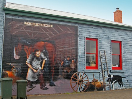
Sheffield is a vibrant, bustling town. It is quite famous for its murals which seem to occupy every blank wall. You can get a free map or even purchase a book from the tourist office to guide you around them all. There are also lots of quirky shops, lots of cafes and food stores to keep you interested. Whatever else you do, seek out the honey shop and try some of the liqueur honeys that are on offer. Very few people will be able to walk out without buying something.
From Sheffield, you have several options. You can return to Devonport the same way. You can ride the 30km back to Devonport on the western side of the Mersey. Take the C150 north out of Sheffield. This is a delightful little road winding its way through some native forest and open farmland before joining the main B14 about 14km from Devonport. This road is busier but mostly has a wide left lane so you won’t feel intimidated by the traffic.
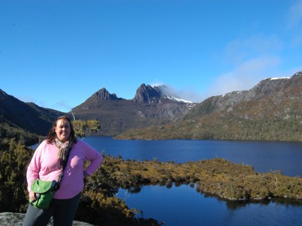
Or you can do what I did and continue on towards Cradle Mountain. It’s only another 50km but there’s almost 1000m of climbing which makes it a tough ride. I cheated and put my bike on the back of Fiona’s car.
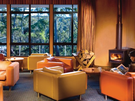
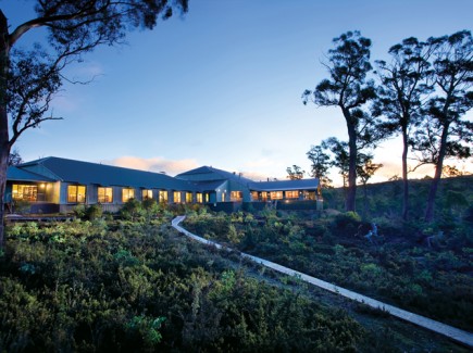
We stayed at Cradle Mountain Chateau just outside the National Park. This is a luxurious resort with very reasonably priced packages outside the main tourist season. They don’t have any bike storage but were happy for me to wander around and find somewhere I was comfortable with to leave my bike. I soon found a balcony under cover where I locked it up. Even if you don’t stay at the Cradle Mountain Chateau, I would recommend their restaurant for dinner.
Jon Miller travelled courtesy of Spirit of Tasmania with accommodation at Cradle Mountain Chateau courtesy of Pure Tasmania.
The Great Escapade Tasmania nine-day bike riding holiday starts in Launceston 9 February and finishes in Port Arthur 17 February.
Ride On content is editorially independent, but is supported financially by members of Bicycle Network. If you enjoy our articles and want to support the future publication of high-quality content, please consider helping out by becoming a member.
One thought on “2”