
Border ranges ramble
The little-used roads south of Brisbane offer gorgeous scenery and challenging hills, finds Andrew Demack.

The rainforest around me is quiet, except for the erratically spaced but insistent ‘ping’ of a dozen bellbirds, which seem to come at me from all points of the compass.
I’m on the Queensland–NSW border, on Lions Road, waiting at the turnoff for the Border Loop Lookout.
The serenity is deafening. My companions have gone down to the Lookout to see the Countrylink XPT train do the Border Loop, also known as the Cougal Spiral. It’s where the Brisbane–Sydney trainline loops back under itself, using two tunnels, so as to fit the railway line into the steep terrain of the Border Ranges.
From the Lookout, tourists (and passing cyclists) can see the XPT emerge from a tunnel into the morning mist (about 9am), disappear again almost straightaway and reappear from another tunnel 30 seconds later. It’s not spectacular, but it is highly unusual!
But from Lions Road to the Lookout is 600 metres of steep downhill, and I decided a rest would suit me better than the steep climb back up to the road after seeing the train pass by.
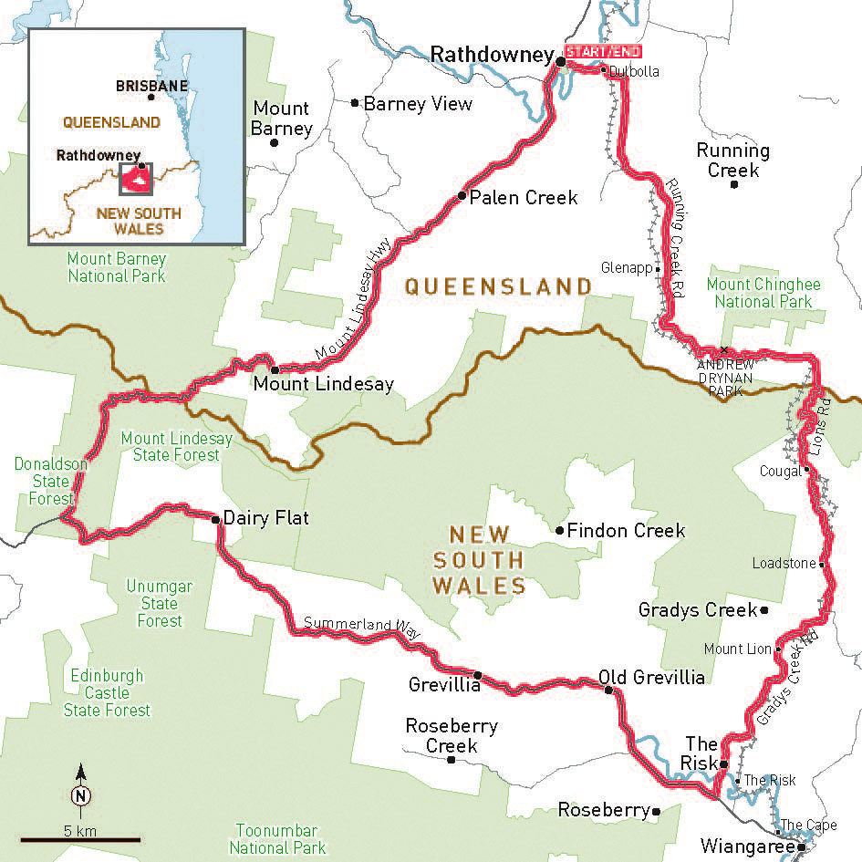
Lions Road is one side of a 120km triangular circuit ride which starts and finishes at Rathdowney.
Rathdowney is a one-pub and one shop town on the Mt Lindesay Highway, 95km south of Brisbane.
Our group of Brisbane southsiders gathered for a 7.15am start from Rathdowney, to give ourselves time to get over the border climb to see the train.
From Rathdowney, Running Creek Road is a single lane of bitumen, snaking through a picturesque valley of farmland. We rode on a Saturday, and shared the road with only a few four-wheel-drives, and a small pack of motorcycle adventurers.
The road passes Mt Chinghee National Park and Andrew Drynan Park, a beautiful campsite beside Running Creek, which in April, at least, more thanlived up to its name.

After gently meandering for 20km, the road decides to go straight up to McPhersons Gap. A couple of short but nasty warm-up hills, and then a 1km stretch of 18% average gradient.
In our group of 10 riders, only four made it to the border gates without some walking.
We crossed the border at 24km, and after a quick detour for trainspotting, descended the range and followed Lions Road towards Gradys Creek and The Risk.
The Lions Road was built by the Lions Club of Kyogle after the NSW State Government refused to construct it in the late 1960s. It was opened as a dirt road in 1971, and became a fully sealed road in 1995. For scenic views it is hard to beat, but on the Queensland sideat least, it has some steep gradients.
After 42km we arrived at Ripples On The Creek, a cafe and retreat on Grady’s Creek, just in time for coffee. With this particular bunch of riders, any time is just in time for coffee.
An hour later we managed to restart the journey. Ripples On The Creek was almost too idyllic, but with almost 80km left, including another major climb, we couldn’t stay all day. Grady’s Creek Road has quite a few single-lane bridges. Five of them have wooden bridge surfaces, but only one is a lengthways ‘pick-a-plank’ bridge. The others have the planks arranged crossways, which makes for a bumpy ride, but is much less likely to catch a front wheel.
After 48km, the ride turns right into the Summerland Way, which runs from Grafton to the border. In this stretch, the Summerland Way follows the Richmond River to its headwaters near Dairy Flat.
There are only two towns of any note, Old Grevillia and Grevillia. I don’t know what happened to require a new town to be built 6km from the original, but it seems to me that more people stayed than left.

But on this trip Grevillia was the saddest sight. The general store is usually a great spot to buy a drink or a snack, but in March the store was totally destroyed by fire. At the time of writing there was no news on whether it would be rebuilt.
The Summerland Way begins to climb just after our first view of Mt Lindesay, with a sign saying Unumgar State Forest. The climb is very gradual at first, and only gets the heart and legs really working in its last 4km. It’s a steady grind of about 6–7% however, a far cry from Lions Road.
At the Summerland Way intersection with Mt Lindesay Highway we made a decision to skip Woodenbong, our planned lunch location. After such a long breakfast at Ripples, we all had enough in the tank for the 38km back to Rathdowney, of which around 15km would be downhill.
Mt Lindesay (1177 metres) dominates the views of this section of the ride. The mountain is a sacred site for the Githabul people, and the summit is under native title.
The road passes through dense rainforest, where once again the sound of bellbirds is louder than the heavy breathing of the rider beside you. Once past the border gate, the road begins to slowly descend, all the while looking back at Mt Lindesay.
Eventually, the road swoops down the hill towards Palen Creek, site of a minimum security prison farm, possibly the nicest place in Queensland to be incarcerated.
Mt Lindesay Highway wanders back and forth across Palen Creek six times in the 18km from the bottom of the descent to Rathdowney.
The Border Ranges circuit ride has almost 1500 metres of vertical ascent in its 120km. But with the only ‘hard’ climb coming very early in the day, we enjoyed a ride that is entirely memorable for both wonderful scenery and quiet roads.
We arrived back at Rathdowney too late to get lunch at the Rathdowney Hotel (it stops serving at 2pm), but found plenty of food in Beaudesert on our way back to Brisbane.
Distance: 120km
Difficulty: Hard
Surface: Sealed road
Scenery: Rural, mountains, rainforest
More information: Tourism information for Rathdowney can be found at www.rathdowney.org.au, or found out about the history of Lions Road at www.bigvolcano.com.au/stories/lionsroad
Ride On content is editorially independent, but is supported financially by members of Bicycle Network. If you enjoy our articles and want to support the future publication of high-quality content, please consider helping out by becoming a member.


Seems 2013 ride has been done.Only just heard about it. Where can I get sign on details etc for next ride and it sounds very good.Keith
Mt Lindesay is the sacred site for the sleep ceremony for the Githabul People