Discover some eastern magic
Cutting through the length of Melbourne’s eastern suburbs before finishing by the seaside, Karen Graham explores a hidden gem of a trail that is full of surprises.
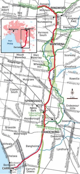
For a trail built to follow a freeway, Melbourne’s EastLink Trail doesn’t run alongside the busy road very often. Instead, it descends into beautiful valleys, winds its ways through bushland and parks, travels alongside rivers and creeks, and skirts the edge of numerous wetland areas. At 35km, it is the longest sealed bike path in the city, created at the same time as the EastLink freeway and as part of the Victorian Government’s commitment to develop Victoria’s cycling networks.
The northern end connects with the Koonung Creek Trail (which in turn links with the Main Yarra Trail to the city centre), and this is a convenient starting point for my Sunday outing with friends who live in Box Hill. It’s a five kilometre ride – mostly uphill – before we arrive at Springvale Road in Donvale, where it meets the freeway, and the EastLink Trail begins.
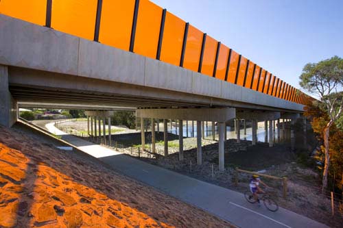
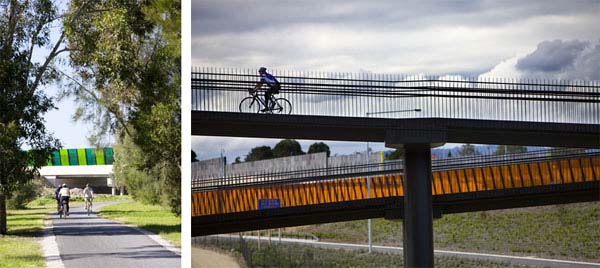
If there is any signage to indicate the start of the trail we don’t see it, but we soon notice the multi-coloured noise barrier walls that separate the bike path from the freeway. This is one of the many colourful architectural elements that characterise this trail.
Riding the route from north to south is by far the easiest option, as the gradient is predominantly downhill, but the first section through Mullum Mullum Valley is challenging in both directions. The trail descends into the valley and climbs over several steep hills, but it’s definitely worth the effort as it’s a beautiful area of native and regenerated bushland.
My heart is pumping and legs straining after the first big hill, but then I enjoy some invigorating freewheeling downhill. Be careful, though. This part of the trail is particularly winding and, on one occasion, I nearly ride off the path because I’m going too fast. One of my companions is also learning to use clip-in pedals and we get a laugh as he stops too suddenly to un-clip in a dignified manner.
Over the years, local residents have worked hard to protect Mullum Mullum from development, including consultation with developers of the EastLink freeway. It is near here that the freeway descends into two tunnels, built specifically to avoid the valley because of its environmental significance.
Mullum Mullum is home to many species of wildlife, including platypus, rakali (water-rats) and koalas, as well as an abundance of birdlife, including swifts, owls, eagles, falcons, rufous night herons, and yellow-tailed black cockatoos.
The phrase “Mullum Mullum” is thought to mean “place of many big birds” and although we only see a few smaller birds flitting from tree to tree, we hear plenty more. It’s such a raucous chorus that I find it hard to believe I’m still in the city. But that’s the wonderful thing about this trail – there’s such a great contrast between the natural and man-made elements along the route.
We’ll be riding through a section of native bushland only to emerge to a boldly-coloured bridge spanning the freeway. Or we’ll be meandering alongside a creek or wetlands and, only a few kilometres later, be stopping to look at sculptured artworks.
Most striking is the sculpture Boy Looking Up by Matt Calvert, which looks like a silhouette as you ride past it. It is part of the EastLink Collection that also includes Hotel by Callum Morton, a rather bizarre scale model of a high-rise hotel, and Ned by Campbell Robertson-Swann, an artwork influenced by Sidney Nolan’s Ned Kelly series.
Around here, the trail also begins to intersect with the Dandenong Creek Trail, which gives you plenty of options for taking an alternative route but is sometimes a bit confusing.
In 2008, just after EastLink opened, I attempted to ride the trail in its entirety as part of my training for the Great Victorian Bike Ride. When I got to Koomba Park I accidentally veered onto the Dandenong Creek Trail, which loops away from the EastLink Trail for a time before rejoining it again at Jells Park.
Unfortunately, I also got confused in Jells Park and took another wrong turn. I only realised my mistake when I arrived back at Koomba Park, having completed a lovely loop of the two trails. Suffice to say, I never made it to the end of the EastLink Trail that day but if you are looking for a short ride, or want to spend more time enjoying Koomba Park or Jells Park, this loop ride is actually a great alternative.
Koomba Park features wetlands and swamps, as well as areas of indigenous vegetation, and there is an abundance of wildlife living in and around the billabongs. It’s a nice place to linger and listen to the frog calls, or enjoy some bird watching in the bird hide. More than 100 bird species have been recorded in this park, including wetland and forest birds.
There are nine kilometres of paths and trails in Jells Park that wind their way through native bush and parklands. There is also another bird hide where, if you are lucky, you can spot darters, cormorants, pelicans, and other migrating birds. On the third Saturday of each month, Jells Park South has a Farmer’s Market where you can browse stalls selling local produce or enjoy a hot breakfast. There are also plenty of shady picnic and barbecue areas if you feel like having lunch after your ride.
We take a detour into Jells Park for a quick coffee break at the kiosk before continuing our ride through the Mulgrave Reserve and the wetlands that are adjacent to it. Today the frogs are making an incredible noise, no doubt appreciating the heavy rainfall of late January (which flooded much of rural Victoria). As we approach the Wellington Road underpass another cyclist informs us that we have our own flood to contend with as there is waist-high water in the tunnel. Unless we want to swim, we’ll need to find another route. Fortunately, there are traffic lights a short distance away and it’s easy enough to double back.
The next section of the trail crosses the freeway several times via a series of EastLink’s distinctive and colourful pedestrian bridges. The trail also leads us across the old railway bridge at Yarraman Station and, for those using public transport to get home, this is an alternative finishing spot.
Another great thing about the EastLink Trail is its ease of accessibility. Heatherdale and Ringwood train stations (on the Belgrave/Lilydale lines) are close to the Mullum Mullum end of the trail, while Noble Park, Yarraman and Dandenong Train Stations (on the Pakenham/Cranbourne lines) are close to the southern end.
There are also options for those who want to continue riding. The Dandenong Creek Trail picks up where the EastLink Trail finishes for a further 10 km ride to the bayside town of Carrum (where there’s another railway station), and from Carrum it’s only a short ride to Chelsea, where the 43km Bayside Trail to Port Melbourne begins.
Our plan is to ride to Carrum, so we cross over the bridge at Yarraman Station and continue riding. The route is a little unclear here, but if you turn left after crossing the bridge you’ll pick up where the trail continues. A short time later, as we approach the Dandenong Bypass, we see that, once again, the trail is completely under water.
The Dandenong Creek has flooded and it’s an impressive sight as murky waters spill over the small bridge that the trail usually crosses. We take an alternative path alongside the road, which gives us the opportunity for a closer view of the impressive sculpture of a blackbird that overlooks the EastLink freeway. Titled Public Art Strategy by Emily Floyd, the sculpture is huge: 13 metres high, 19 metres long, and 7.5 metres wide at the wing span.
From here it’s only a short ride to the end of the EastLink Trail at Greens Road, where we continue riding along the Dandenong Creek Trail. For the first time today we are riding on gravel, but it’s well-graded and a lovely ride through floodplains to the point where the Dandenong Creek joins Mordialloc Creek and Patterson River.
The day began in misty and overcast conditions, but now the sun has emerged and it’s a beautiful summer’s day. Our progress is slowed for the final kilometre by crowds also enjoying the day – walking, bike riding, and fishing on the banks of the Patterson River. As we cross a small pedestrian bridge we get a glimpse into the Patterson Lakes Marina, which is the largest marina in Victoria, and then we arrive at the coast.
There are plenty of options for lunch in the area (including the marina, Carrum shops, and the Seaford foreshore) – and after 50km on the bikes we feel we’ve earned our fish and chips on the beach.