
Two wheels to The Tip
Rainforest, sand, mud and crocs—what could be a better bike adventure than the trek to Cape York? Jon Miller rode 1,600km and made it back to tell the tale.

I am riding along a dusty, corrugated road in far north Queensland. A car coming the other way, pulls up a little ahead of me. As I approach, the driver winds down his window, pokes his head out and asks “Do you want a banana?” This generosity is typical of that encountered on my mammoth ride from Cairns to the tip of Cape York. So much so, that when people ask me about the highlights of the trip, “The kindness of strangers” is my answer. Countless people we met along the way offered us food and water, made us tea and coffee, took our rubbish or, on one memorable occasion, heated water for us to wash after a particularly muddy day.
Of course there were many other highlights too: the Daintree, the birdlife, Iron Range National Park, Old Telegraph Track, Lakefield National Park.
I had wanted to do this ride for some time, and had done some research four or five years previously. For one reason or another, that trip fell through. So when my friend Claire proposed the trip to the membership of Melbourne Bicycle Touring Club about 12 months ago, I jumped at the chance. Four or five others showed interest in the trip but none of them ended up doing it so there was just the two of us.
We started the ride in June, flying out of Melbourne on a cold and wintry day. It was a bit of a shock, but a pleasant one, to arrive in Cairns three hours later to a warm and sunny day. Our contact, Rob, who met us at the airport, said the previous night had been quite cool, dropping down to 20 degrees. I had to laugh, getting up to 20 degrees in the middle of the day is a stretch at that time of year for Melbourne weather.
We had to stop in Cairns for a couple of nights to stock upon food and other supplies for the trip. This time really dragged for me. With this trip in the pipeline for so long, we were so close to starting that I was itching to get going.

Coast Road to Cooktown
Finally, it was time to leave. We rode up the Kuranda Range to the township of Kuranda, which turned out to be a mistake. The Kuranda Tourist Railway is quite famous for the views you get as the train labours up the mountain-side. We were hoping for similar views but that wasn’t to be as the surrounding rainforest was too dense. On top of that, the traffic was very heavy on the narrow winding road. It was not the best way to start the trip and we were both very glad to arrive in Kuranda.
 After spending some time exploring the town, we followed a little-used road for most of the day along the top of the Black Mountain Range. The road wound its way through the rainforest and we only saw a handful of cars, which was a relief from the busyness of the morning’s ride. We then dropped back down to the coast for our first night’s camp on the beach.
For the next few days, we followed Cook Highway towards Cape Tribulation. Despite this being the main highway north, there wasn’t very much traffic. The prevailing southerly wind, which we would have for most of the trip, had kicked in too. Flat bitumen roads, glorious sunshine, magical scenery and a tail wind to boot: it doesn’t get much better.
We crossed the Daintree River by ferry just south of Cape Trib and soon entered Daintree National Park, famous around the world for where the rainforest meets the sea. There were some steep climbs here but the scenery was just amazing and easily distracted us from our toil. There were many short walks to do and expansive views to admire. I felt truly inspired by the vibrancy of the rainforest—it was so lush and alive. Bike riding has to be one of the best ways to experience it. Dense walls of vegetation line the road and it’s teeming with bird and insect life. The smells and sounds of the rainforest are all around and you feel so much a part of it. I was glad I wasn’t stuck inside a car.
Emmagen Creek was another significant point: it was the first of over 100 creeks, rivers and streams that we had to ford. We were both very aware of the crocodile risk. It was only about a foot deep; we waded across nervously with no sign of any crocs.
Cape Tribulation marks the start of The Bloomfield Track. This road was controversially carved through The Daintree in the early 1980s. To minimise the damage to the environment, the road took the shortest practical route: straight up hillsides rather than winding gently around following contour lines. Gradients reached 15–20% and approached 33% occasionally. The steepest sections were unrideable, both of us had to push each bike up the steep inclines for a few dozen metres. Our rest was the walk back down to get the other bike. This was slow and tiring work, one 300 metre section took us about half an hour to cover. But it was mostly rideable, albeit in our 24×32 granny gears.
Lakefield National Park
At over half a million hectares, Lakefield National Park is bigger than some countries and it took us several days to ride across. It lies to the north west of Cooktown and, as it is a little off the main road, many travellers bypass it. They don’t know what they have missed.
 We almost missed it ourselves—an unusual, late season cyclone in May had delayed the opening of the national park after the wet season. When we flew out of Melbourne, large parts were still closed. While it was due to open by the time we arrived, there were no guarantees. We were much relieved when we met some travellers coming the other way who told us the road was clear. The park is a vast expanse of waterholes, rivers, creeks, lagoons and wetlands; it is crawling with wildlife, particularly birds. We recorded eighty different species of birds throughout the trip and many of these were sighted in Lakefield: jabiru, brolgas, geese, kites, cormorants, egrets, bee-eaters and more. It’s also where we saw our only crocodiles for the trip. Fortunately, all of these crocodiles were at a safe distance but it was still a bit unnerving fording creeks and rivers knowing they were about.
As the trip progressed, we got more and more blasé about the possible presence of crocodiles, though the thought that they were probably lurking was always in the back of our minds.
We emerged from Lakefield on to the Peninsula Development Road, the main road between Cairns and Weipa. It was very busy, dusty and badly corrugated, and it took us about a day and a half to arrive at the small aboriginal township of Coen. We had half a rest day in Coen, which allowed us to stock up on food at the general store, retrieve a food parcel that Claire had mailed to herself before we left, indulge in hot showers, wash all our clothes in a washing machine and go out to the pub for dinner. After two weeks on the road, we felt very pampered by these small luxuries.
Iron Range
The next morning we were back heading north on the Development Road and enduring the dry and dusty conditions, it was another day and a half of riding before we could turn off it. Just before the turn, we met Gavin who gave us the bananas mentioned earlier. This small act of kindness lifted our spirits no end; our days on the Development Road had really sapped our enthusiasm.
 Iron Range National Park is Australia’s largest area of lowland tropical rainforest, it lies on the east coast of Cape York Peninsula and involved a six day detour from the direct route: two days to ride in, a rest day in the National Park and three days to ride out.
The ride in involved climbing over the northern tip of The Great Dividing Range to get back to the East Coast. These were the first real hills we’d encountered since leaving Cooktown over a week ago and we were feeling the strain of climbing again. By now, the weather had started to close in a bit so views were limited and the rain turned the dusty road to thick mud. A couple of kilometres of road works didn’t help the mud situation either. By the time we arrived at our camp site on Chilli Beach, we were exhausted and both us and our bikes were covered in it. We had met and befriended some people travelling by 4WD in Coen a few days previously. They were nice enough to heat up some water for us to wash in—the kindness of strangers.
We decided to have a rest day in Chilli Beach to wash clothes and service the bikes but also to relax and enjoy the rainforest. We went for a walk to the nearby town of Portland Roads, primarily to visit Out of the Blue cafe we had heard about. Unfortunately, it was closed the day we were there.
Frenchmans Track
There are two roads going into the Iron Range National Park, the main road we came in on and Frenchmans Track. Frenchmans is little used due to a notoriously difficult crossing of the Pascoe River; both banks are very steep, the water is deep and fast-flowing and it’s prime croc territory. We’d met a handful of people over the past couple  of days who gave us conflicting advice about Frenchmans. Half the people said we’d have no problems and the other half, including the ranger at the National Park, said not to go.
We decided to give it a try as the Pascoe crossing was only about 10km from the turn-off. If it proved too hard, we could turn back with not much time lost.
The crossing turned out to be just as treacherous as we had been led to believe. We were lucky to encounter three car loads of people coming the other way just as we arrived at the river. As well as scaring off any crocs that may have been lurking, they would have been able to assist if we had any difficulty.
It took us 90 minutes to get across, we had to unload the bikes and carry them over our heads as we waded through waist deep water. Then go back for the panniers. Even after the crossing, it wasn’t exactly plain sailing, the track was a mixture of deep sand, loose gravel, and deep ruts. There was much pushing of the bikes as we struggled onwards. The scenery was well worth the effort with the classic outback red roads, green vegetation and bright blue sky, and magnificent views back to the coast.
Old Telegraph Track
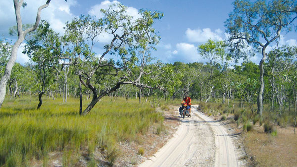
The road north originally followed the telegraph line which was as straight as possible to minimise the amount of expensive copper wire needed. It traversed the low-lying areas and many creek crossings were involved. When the telephone replaced the telegraph, the same line was used to transmit the phone signals until the mid-1980s when it was replaced with a more reliable microwave link. The microwave repeater stations had to be placed on hill tops so the Bamaga Road was built to facilitate this, bypassing much of the Old Telegraph Track which hasn’t been maintained since the new road was built.
Nowadays, most of the traffic takes the bypass road as it’s in much better condition. Only intrepid 4WDrivers and slightly deranged cycle tourists take the Old Telegraph Track. This is on account of the numerous creek crossings. They either have deep water, steep and slippery banks, large rocks in the beds or a combination of all of these. The local towing services and mechanics make a decent living as a result; 100 cars are reportedly dragged out of the creeks each year. There’s little danger of that happening on a bike of course but the OTT presents other challenges to riders. Many of the creeks were so deep we had to unload the bikes and ferry our gear across; it was often difficult getting the bikes down to and up from the water. On top of that, the road was often sandy which meant pushing the bikes. Without doubt, the Old Telegraph was one of the most difficult parts of the whole trip.
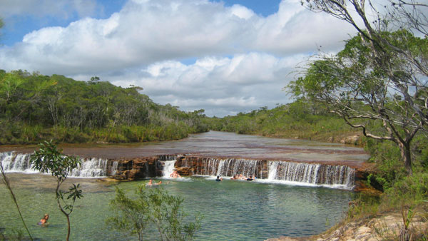
But it wasn’t all hard work. Fruit Bat Falls and Eliot Falls are both gorgeous places. They have natural swimming holes and the advantage of being high enough and far enough inland to be devoid of crocs. Any that do make their way there are soon removed by the Queensland Parks Service. We spent quite a bit of time at both of these places enjoying the warm, crystal clear water—along with dozens of other people.
The Tip
We emerged from the Old Telegraph Track and it was still another three days of riding, on mostly good roads, to The Tip, the northernmost point of mainland Australia.

We were still two days away from our ultimate goal when there was a moment of panic: my left hand crank disconnected itself from the Hollowtech bottom bracket. There had been a handful of minor mechanical issues on the ride so far but this was serious. Fortunately I was able to re-attach the crank but it took me quite a few tries before I got it right.
The road north finishes about 500 metres from The Tip. Surprisingly, there is no path from there, people just make their way over the rocks the best they can.
It’s quite a moving experience standing on the top of Australia. We’d been riding for almost four weeks by then and covered nearly 1600 kilometres; not to mention the months of planning that was done beforehand. To have finally reached our goal after so much effort was almost unbelievable.
In one respect, it was a relief to get there but it was also a bit sad—the adventure was over. We still had a few days to kill and spent them exploring the northern parts of Cape York but we’d done what we set out to do and it was all a bit anticlimactic.
We returned to Cairns via sea. A container ship makes the trip up from Cairns once a week and there is room for a small number of passengers. Sailing back south over two days was a very relaxing way to finish.
The roads
Most of the first week from Cairns to Cooktown is sealed. The exception is Black Mountain Road and also the section north of Cape Tribulation until it meets the Mulligan Highway. There are a couple of kilometres of bitumen through the township of Wujal.
The dirt starts in earnest outside Cooktown. It’s almost all unsealed from then on. There are patches of bitumen along the way but mostly these aren’t more than four or five kilometres. The most notable sections are about 10 kilometres either side of Coen, about 5 kilometres south of Bamaga and two or three sections of around 10 kilometres on the road going in to Iron Range National Park.
For Jon’s trip blog, see http://www.crazyguyonabike.com/doc/CrocCatcher
Ride On content is editorially independent, but is supported financially by members of Bicycle Network. If you enjoy our articles and want to support the future publication of high-quality content, please consider helping out by becoming a member.


This looks like an awesome route for the tour! I will be saving this route for the future when I hope to tour in Australia.
Nice trip, sounds like quite the adventure
Nice write up! I am curious about the boat trip back, how did you organise it, can you just turn up? Thanks
The boat normally books out months in advance and it only runs once a week so I wouldn’t recommend just turning up. Details are on the Sea Swift web site.