
Golden Trails
The Goldfields Track is filled with historic scenery, beautiful rainforest and a treat or two for weary travellers finds Jon Miller.
Immersing oneself in the gloriously warm waters of the spa at Hepburn Springs Bath House must be one of the best ways to finish a day’s ride. Especially if that ride is a stage of the Goldfields Track (day two of a four day ride) and you’re dirty, tired and sweaty, having ridden 70km on dirt tracks through the bush.
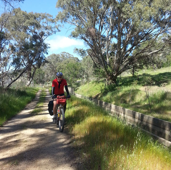
The Goldfields Track is a 210km long shared path between the towns of Buninyong and Bendigo in Central Victoria. It started out as the Dry Diggings Track which opened back in 1995 as a 60km walking track between the old Victorian gold mining towns of Castlemaine and Daylesford.
It was gradually extended over the years to include the Leanganook, Dry Diggings and Wallaby Tracks run together.
In 2011, after receiving half a million dollars from the Federal Government, the Goldfields Track was upgraded to make it a shared mountain bike and walking trail. It is now the longest such path in Victoria.
Wallaby Track
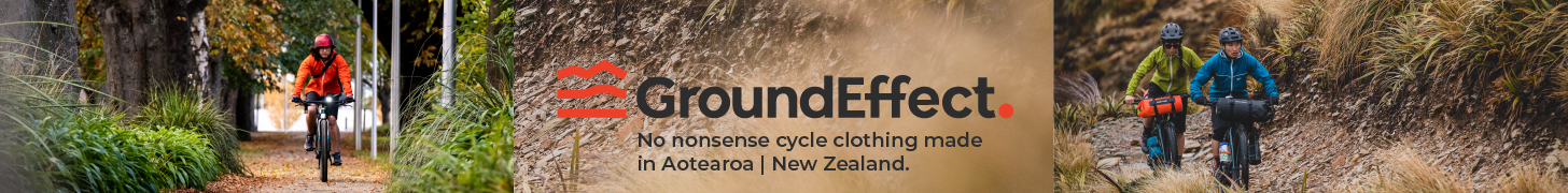
At 90km, the Wallaby Track from Mt Buninyong to Daylesford was a big ride for us to complete in a day, so we split it up into two. We arrived in Ballarat by train, left our gear at the hotel we were staying in and set off towards Mt Buninyong, 25km away. This part of the Wallaby Track was almost all on wide, flat shared paths. While it was quite pretty to start with, skirting the Yarrowee Wetlands and following the Yarrowee Creek, a lot of the path after that ran next to the busy Geelong Road—hardley the remote mountain biking experience we were after.
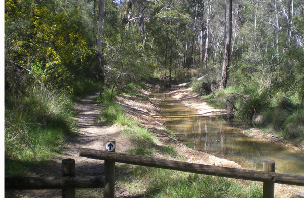
On day two, we headed north out of Ballarat towards Creswick. There was about 5km along the Yarrowee Creek, then the track passed underneath the Western Freeway and we entered Nerrina Historic Reserve. From there on it was glorious singletrack and doubletrack through open native forest. It was good flowing riding with the only complaint being that it was mostly uphill.
Just before Creswick, there are a couple of campsites at Slaty Creek. There is normally water in the creek and visitors are advised to treat it before drinking.
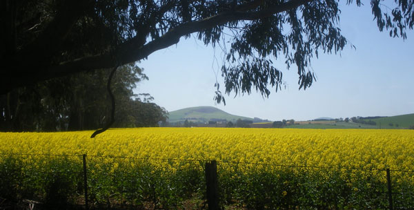
After Creswick, there was about 10km of riding on mostly bitumen roads through open farmland. It was good to get some speed up after the long uphill slog we’d had so far. There were some beautiful views of lush, green pastures, red ploughed fields and golden canola crops.
The final run into Daylesford (and our awaiting spa) was through spectacular forest. The first section follows the route of the old Anderson Tramway. There is an impressive cutting, several kilometres in length, to ride through followed by more singletrack to Sailors Falls on the edge of Hepburn Regional Park. Water is available from a natural mineral spring at Sailors Falls. There’s plenty of accommodation in Daylesford, but we were staying 6km further down the road at Continental House in Hepburn Springs—a refurbished 1920s guest house. Owners Veronica and Steve were very friendly and helpful, driving us to the aforementioned spa for a relaxing soak then out to dinner at the Old Hepburn Hotel. The pub has good cyclist-sized servings and a band playing most weekends.
Dry Diggings Track
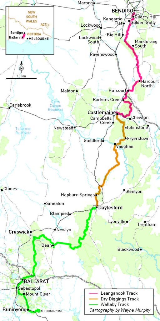
The 61km Dry Diggings Track between Daylesford and Castlemaine is easily the best part of the Goldfields Track. If you’ve only got one day, this is the section to ride. Lots of free-flowing singletrack, mostly downhill, and gold rush-era ruins dotted along the way.
There’s a bit of climbing from Hepburn Springs, including some steep sections we had to walk. However, we were soon rewarded for our efforts when we arrived at the Chocolate Mill, conveniently situated where the track crosses Midland Highway. (There’s a café with hand-made chocolates for sale).
The downhill started after the Chocolate Mill with arguably the best riding of the trip which went through the Castlemaine Diggings National Heritage Park. We stopped to look at some of the relics—water races, stone walls and the impressive Garfield Water Wheel. The stone supports are all that remain of the 72 foot timber wheel, built to power a quartz crushing plant in the 1880s.
Vaughan Springs was a pleasant place to stop. There’s picnic shelters, play equipment and natural spring water to fill bidons with.
The track follows the Poverty Gully Water Race into Castlemaine but we pushed on to Harcourt where we stayed at a converted scout hall called, funnily enough, The Scout Hall—up-market accommodation with bike racks located just inside the front door. That night we went out to dinner at the nearby Tread Harcourt—a motel and restaurant run by Andy and Paula who are active riders and heavily involved with the Goldfields Track Association.
Leanganook Track
This is the shortest day at 58km from Castlemaine to Bendigo (even less if you overnight at Harcourt like we did) and also the least technical riding. It’s perfect if you’re looking for an early finish in order to catch a train back to Melbourne.
The track profile on the website shows a big climb over Mt Alexander just after leaving Castlemaine. I was very much dreading this after three long days on the bike so far. It turns out that Mt Alexander Regional Park is an ecologically sensitive area. You can argue the merits of this all you like but the bottom line is, bikes aren’t allowed. What this means for track riders is there is quite a long diversion; it’s a mixed blessing though—it avoids a killer climb but most of it is on bitumen. Another off-road route is planned which will skirt the base of the mountain and also pass next to the MTB park in Harcourt.
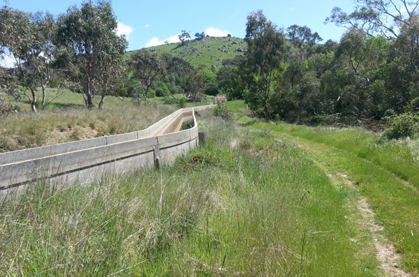
The Coliban water channel was constructed in 1856 to carry water 70km from the Great Dividing Range to Bendigo. While it’s no longer in use, it is largely intact along with many of the original features. The Goldfields Track follows the channel most of the way into Bendigo. It’s mostly flat riding on good quality double-track so consequently, quite fast. There are a couple of places where the channel tunnels through hillsides; riders have to climb up over these hills which are steep and sometimes rocky.
The water channel finishes at Sandhurst Reservoir, about 10km from Bendigo. From there, it’s mainly single track into town. Keep an eye out for marker posts as there are a lot of unmapped tracks leading off into the forest. The Goldfields Track is signposted right through to Bendigo railway station.
Logistics
Access to the Goldfields Track is quite straightforward with V/Line train services running to the towns of Ballarat, Creswick, Castlemaine and Bendigo every hour or so. These towns, along with Daylesford, Hepburn Springs and Harcourt have multiple accommodation options to suit a range of budgets. Do support the cycle-friendly businesses that are featured on the Goldfields Track website as they support the track. Some of these also provide packed lunches for the day’s ride.
Reliable drinking water is only available at the towns, though natural spring water can be found at various locations near Daylesford and Hepburn Springs. The Goldfields Track Association is working with land managers on the route to arrange for water tanks to be installed. Until then, ensure that you carry plenty with you.
Find out more at the Goldfields Track website. While we chose to carry our own gear, some accommodation providers will shuttle luggage between the towns for you. Contact the Goldfields Track Association for details.
Jon rode the Goldfields Track with the assistance of the Goldfields Track Association and its commercial partners.
Ride On content is editorially independent, but is supported financially by members of Bicycle Network. If you enjoy our articles and want to support the future publication of high-quality content, please consider helping out by becoming a member.


What type of bike would be recommended to do this ride? MTV only or could you use a cx/gravel grinder type bike?
Hey Jamie
Our writer, Jon Miller, said that’s a hard question because it depends on the competence of the rider. But he offered this advice: “I think with the Goldfields Track, if you have support, aren’t carrying gear and are confident on single track, you could do most of it on a CX bike. If you’re carrying everything, I’d definitely recommend MTB.” Hope that helps.
Thanks for email.
Would love to plan this trip for 2015 with a friend from Benalla. we could meet at Bendigo and travel south from there. Then train back to Bendigo from whereever. M.
If considering riding with a fully-loaded bike and panniers, beware of the real risk of clipping trees*. I’d recommend doing it using fixed accommodation and riding with just a saddle pack, handlebar bag and/or backpack.
*Had a mate go headfirst into the mud of the Poverty Gully water-race because of this.
The Coliban Main water channel pictured has actually never ceased being used. It is in fact still the only way that water gets from Malmsbury reservoir to Bendigo. It generally only operates from September to June each year however to allow some down time for repairs and maintenance. Good article and thanks for the tips!