
Island hopping on two wheels
Arlen Keen goes island hopping on Japan’s Shimanami Kaido bike route.
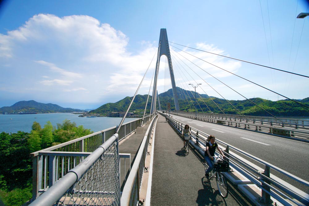
The ‘Shimanami Kaido’ or ‘Sea Route’ is an impressive feat of engineering—a 60km islandhopping expressway opened in 1999 to link the main Japanese islands of Honshu and Shikoku by road. The expressway bounces across half a dozen tiny islands in the Seto Inland Sea, thanks to a series of architecturally diverse suspension bridges.
At the time of the expressway’s construction, a fully separated bike and pedestrian route was built along-side, complete with bike-friendly bridge access, making the ride a reasonable option for just about anyone. With nine members in our rolling posse, all of varying skill levels, this was a welcome reassurance.
We started in Onomichi, the sea-side town on Honshu island. It’s about an hour east of Hiroshima on the “slow” train (relative term), and 90 minutes west of Osaka via the Shinkansen (bullet train) with one change to a slower train in Fukuyama.
Emerging from Onomichi station into the bright sunshine of a quaint port-side plaza, we experienced our first hiccup. Despite the availability of rental bikes at 14 different points along the route, the most important hire location, at Onomichi, was nowhere to be found. We did eventually stumble across it, about 300 meters west of the train station entrance, around the back of an information mall and in the lower level of a car park. The location is not at all obvious and poorly signed, so a keen eye and a Japanese phrasebook come in handy here.
The hire bikes are par-for-the-course Japanese shop bikes, with heavy baskets on the front, poor handling and clunky frames, so don’t expect to be able to zip along at anything above 10km/h. However, as speed wasn’t an option, we were able to really soak up the scenery. All the bikes were uniformly priced at 500 Japanese Yen per day (about $6.25AUD) with an extra fee of 1000 Yen if the bikes were not returned to the original location. We planned to pick up the train at the other end of the ride for our next destination, so this was a one-way trip from the outset and we gladly paid. Note, like much in Japan it is cash only.
Much to our surprise, the first leg of the trip consisted of a fi ve minute ferry ride from Onomichi port on the mainland to the first island. Make sure you have 110 Yen worth of coins to pay the 85-year-old ferrymaster/grandmother. Before finding the ferry, which was in a much more obvious location than the bike hire, make sure to pre-buy a booklet of bridge tolls for the ride ahead from the tourist office at Onomichi Station. Tolls paid in cash across the ride total 500 Yen, but the pre-purchased booklet is good value at 250 Yen instead, and saves fumbling for unfamiliar coins.
The riding route is marked with blue lane paint along the entire distance, so off we set, without a map, following the thin blue line. Our goal was to reach our accommodation at the happily named Sunset Beach on the midway island of Ikuchishima in time to enjoy, you guessed it, sunset.
Given the heat and humidity of Japanese summer, our decision to start the ride at 3pm wasn’t the best choice. But we coped by setting a leisurely pace marked by frequent stops for cold drinks and ice creams available from the ubiquitous vending machine and convenience store network. Convenience stores in Japan offer a good selection of quality food on the cheap (think fresh sushi trays and huge ranges of exotic drinks), so keep an eye out for the familiar 7-Eleven logo and the English-signed Lawson chain. This was handy because it turned out we couldn’t rely on finding a restaurant or café that was open in these country island towns.
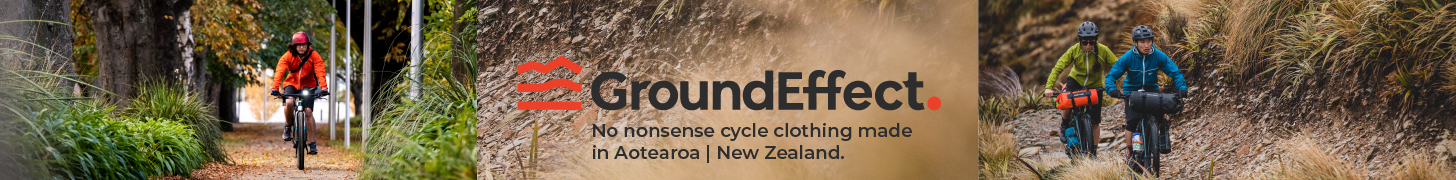
We approached the first of the six suspension bridges that we would encounter by about 4:30pm, and, paying our toll, we headed out across the sea, taking in the first of many spectacular views of the surrounding islands. Though the gradient was shallow, the heat made climbing more difficult than we’d expected, and the descent at the far side of the first bridge came as a welcome relief.
The islands proved to be quiet destinations, filled with people simply going about their daily business. Depending on the island, this day-today activity was vastly different. Early in the ride, rice paddies and tropical fruit groves interspersed with metalwork shops and other small-scale industry dotted the street-cape. At the time it
seemed an incongruous mix, but later made total sense.
As the heat of the day waned we continued to tap out a good rhythm towards our evening destination. The sunset caught up with us by about 7pm as Japan doesn’t do daylight savings time. We rolled up to our beach-side lodgings just as the sun was setting across the ocean.
Unfortunately, we were a bit too relaxed for our hosts, turning up to our lodgings at a family-run inn called Setoda Tarumi Onsen much later than indicated in our booking. We quickly learned that this is frowned upon in Japan, and the courteous thing would have been to call ahead and let them know we would be late. However, this didn’t stop our hosts laying out a traditional Japanese dinner, high in protein and carbs (i.e. fi sh and rice), which was just what we needed. After dinner we soaked our weary limbs in the on-site spa with a view out over the beach and the fading sunlight playing across calm ocean waters. Then we retired early, agreeing on a 6:30am start the next day in a vain attempt to beat the worst of the heat. Dinner and bed at Setoda Tarumi ran to 4200 Yen per person (about $50AUD), providing yet more evidence that Japan is a less expensive destination than commonly thought.
Day two dawned cloudy, but still warm, and a few of our group worried about the possibility of tropical rain. However, by the time we reached the first Lawson’s, the sun broke through and we stopped to apply sunscreen and breakfast on yoghurt cups, sport drinks and sweet buns.
As we approached our final destination of Imabari, an industrial port city and our entry point to the island of Shikoku, the scenery, both natural and constructed, became even more spectacular and unexpected. After about an hour of riding, we rounded a bend to be met with the beginnings of a large-scale industrial ship-building complex, one that would stretch across the remaining islands—which was certainly not something we expected to come across on a leisurely tourist ride by the sea. The final suspension bridge of the ride, a 6km-long behemoth, gave us a brilliant view of the shipyards below. The end of the bridge offered the most enjoyable descent of the trip, with a series of wide, easily curved switchback ramps speeding us down the last hill and depositing us within a couple of kilometers of easy riding from Imabari station and our hire bike docking station.
Depositing the bikes proved to be a similar experience to picking them up; with a bit of searching necessary to spot the correct empty lot. However, this time we were prepared, and with nine-pairs of eyes looking, it wasn’t too hard to find. We repaired to the train station, bento boxes in hand, to be whisked to our next destination: the nearby outdoor art island of Naoshima.
If you can manage to bring your own bike it would undoubtedly make the Shimanami Kaido a more comfortable ride. But nothing can really be done to enhance the unique experience of the ride itself, which ensures it will maintain a secure place among my many fond memories of Japan.

After riding the Shimanami Kaido you might like to tour the island of Shikoku on the traditional pilgrimage of 88 temples. Tony Gibb tells the tale of his O-Shikoku tour.
Ride On content is editorially independent, but is supported financially by members of Bicycle Network Victoria. If you enjoy our articles and want to support the future publication of high-quality content, please consider helping out by becoming a member.


I have brought a couple of Tony’s books (Shikoku & Hokkaido) and was wondering if I could get a better resolution( more detailed) map of the Hokkaido route.
Ken, I use a GPS and an English version of the map of Japan. I have all the temples logged on the GPS. The maps are derived from the GPS support software – called Mapsource. I can supply the locations if that would help.
The Hokkaido route is pretty straightforward as the country is still open and there aren’t many intricate local layouts. Please contact me if you want more via this website.
Thanks Tony,
We are starring in Nemuro up to Rausu and then to Wakkanani. And as you say it is pretty straightforward. I’ve plotted it all out using RidewithGPS.
Do you know if there are any tunnels on this course?
At
Ken
Hi Ken. have checked my journal and memory and don’t recall any significant tunnels between Nemuro and Wakanai, but I did some of that distance by train or bus. The monster tunnels were the ones I encountered before Wakanai (going clockwise). These were pretty scary – 3kms long with no bike path and plenty of (admittedly careful) trucks. The NE coast is pretty flat and a bit less iteresting than the West, The Abashiri to Tokoro Cycle Path is nighlight but only about 35kms long as I recall.
Good luck with the ride. You won’t regret it.
Tony, I am trying to book the hotel at Setoda as you recommended but the description is very general – could you post a link or street address or telephone number please?